Log in
All resources
Create a design
4,886 Free Images of Map Lichen
bibliothèque nationale de france
map collection of leibniz-institut für länderkunde
philippe de la rué
john rocque
postcards published by mid-west map
paper
british museum
curt teich postcard archives
map of maastricht by willem and johannes blaeu (1649)
german renaissance,northern renaissance
map modeling in geography (1894)
ghosts & ghoulish scenes
curt teich postcard archives
postcards of oklahoma city
propaganda map
1529 maps
maps by girolamo ruscelli
1570s maps of india
david rumsey historical map collection
andrew dury
polish-russian war 1609-1618
sigismund's map of moscow
america
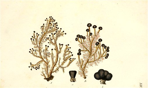
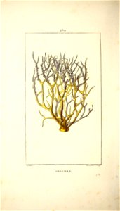
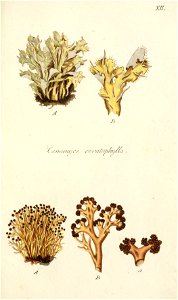
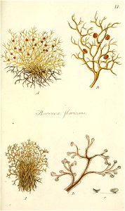
coral
map of vienna by jacob hoefnagel
drawings of churches
map of vienna by jacob hoefnagel
stubenbrücke
1840s maps of the world
german renaissance
maps of paris from the david rumsey historical map collection
maps of paris by braun & hogenberg
john rocque's 1746 map of london
kensington gardens in art
map of bruges by marcus gheeraerts (i)
drawings in the groeningemuseum
jodocus hondius ii, nova totius terrarum orbis geographica ac hydrographica tabula, 1636
map
postcards of motels in california
curt teich postcard archives
henricus hondius ii, nova totius terrarum orbis geographica ac hydrographica tabula, 1630
eran laor cartographic collection
topographia bohemiae moraviae et silesiae (merian)
baroque
john rocque's 1746 map of london
old and new london (book)
maps from the earth and its inhabitants, vol. x
maps of ancient nubia
the comprehensive history of england (1876)
historical images of st. james's palace
arnold van langren map of east africa
1596 maps of africa
maps of ghent by armand heins
map of expo 1913
map of maastricht by willem and johannes blaeu (1649)
first medieval city wall of maastricht
hendrik van langren map of south asia
1600 maps of asia
geographia universalis (1545) in the british museum
german renaissance,northern renaissance
british library king's topographical collection
map of paris by françois van hoey
map of modern syria by philippe de la rué
1650s maps of palestine
geographia universalis (1545) in the british museum
german renaissance,northern renaissance
hendrik van langren map of south asia
1595 maps of asia
geographia universalis (1545) in the british museum
german renaissance,northern renaissance
geographia universalis (1545) in the british museum
german renaissance,northern renaissance
hendrik van langren map of south asia
1595 maps of asia
geographia universalis (1545) in the british museum
german renaissance,northern renaissance
maps of the bely gorod
baroque
turgot map of paris, kyoto university library – derivative files
palais royal (1634–1763)
map of the german empire by louis stanislas d'arcy de la rochette
1782 maps of the holy roman empire
historical map collection
maps of new france
maps of the ottoman empire by mercator-hondius
eran laor cartographic collection
map of amsterdam by gerrit de broen (ii)
maps in the rijksmuseum amsterdam
map of amsterdam by gerrit de broen (ii)
maps in the rijksmuseum amsterdam
map of amsterdam by gerrit de broen (ii)
maps in the stadsarchief amsterdam
nicolas sanson. “mappe-monde, ou carte generale du monde.”
1667 map of madagascar by guillaume sanson
john rocque's 1748 map of london and adjacent country
a history of london (1884)
turgot map of paris, kyoto university library – derivative files
couvent des filles-saint-thomas
map of amsterdam by gerrit de broen (ii)
maps in the rijksmuseum amsterdam
john rocque's 1748 map of london and adjacent country
a history of london (1884)
brazilian paintings in the museu antônio parreiras
luiz christophe
collège de lisieux
collège du plessis
hôtel de choiseul (rue de richelieu)
salle favart i
turgot map of paris – derivative files
old maps of île saint-louis
john rocque's 1746 map of london
marlborough house, london
map of the circle of austria by sanson
maps by nicolas sanson
map of ancient asia minor by philippe de la rué
bibliothèque nationale de france
map collection of leibniz-institut für länderkunde
1720s maps of the iberian peninsula
map collection of leibniz-institut für länderkunde
1680s maps of the netherlands
map of ancient asia minor by philippe de la rué
bibliothèque nationale de france
map of ancient asia minor by philippe de la rué
bibliothèque nationale de france
map of ancient asia minor by philippe de la rué
bibliothèque nationale de france
map of paris by braun & hogenberg - derivative files
rue de braque on maps
map of ancient asia minor by philippe de la rué
bibliothèque nationale de france
map of maastricht by willem and johannes blaeu (1649)
jekerkwartier (maastricht)
map of bruges by marcus gheeraerts (i)
1562 maps
postcards of elk city, oklahoma
curt teich postcard archives
german renaissance
stabius world map
map of maastricht by willem and johannes blaeu (1649)
meuse river in maastricht
maps by jan janssonius
1650s maps of romania
vegetables
plants
america
coral
america
coral
america
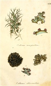
lichen
cartography
maps
historical map collection
maps by john cary
maps in the library of congress
1670 maps
map of ancient armenia by philippe de la rué
eran laor cartographic collection
curt teich postcard archives, curt teich & company
postcards of cook county, illinois
1590s maps of the levant
ptolemy's 4th asian map
curt teich postcard archives, curt teich & company
map postcards
postcards of madison county, illinois
curt teich postcard archives
windmills in amsterdam
singelgracht
postcards of creek county, oklahoma
curt teich postcard archives
map collection of leibniz-institut für länderkunde
maps of liège by baptista van doetecum
map collection of leibniz-institut für länderkunde
maps of liège by baptista van doetecum
map collection of leibniz-institut für länderkunde
maps of liège by baptista van doetecum
carta hydrographica y chorographica de las yslas filipinas
baroque painting
turgot map of paris, kyoto university library – derivative files
plans of the palais des tuileries
map collection of leibniz-institut für länderkunde
1800s maps of the world
old hemisphere world maps (partner files)
1800s maps of the world
old maps of the northern hemisphere
1800s maps of the world
map of modern syria by philippe de la rué
1650s maps of palestine
old maps of amsterdam
hendrik de leth
backs of postcards in curt teich postcard archives
postcards of miami, oklahoma
map of maastricht by willem and johannes blaeu (1649)
grote gracht (maastricht)
map of maastricht by willem and johannes blaeu (1649)
kleine gracht (maastricht)
john rocque's 1746 map of london
old and new london (book)
backs of postcards in curt teich postcard archives
postcards of clinton, oklahoma
map of paris by jouvin de rochefort (boutier 112)
maps of paris from geographicus
atlas géographique des quatre parties du monde (delisle)
map of europe by guillaume delisle (1700)
sanson map of the german empire (17th century)
sanson maps of the circles of germany
john rocque's 1748 map of london and adjacent country
maps in the british museum
sanson map of the german empire (17th century)
sanson maps of the circles of germany
2601 - 2700 of 4,886
Next page
/ 49


![[View of Paris]. / Franciscus Hoiamis fecit., François Van Hoey, 1619](https://cdn.creazilla.com/illustrations/10000789014/view-of-paris-franciscus-hoiamis-fecit-franois-van-hoey-1619-lg.jpg)


![Manatvs located on the Noot [sic] Riuier., 1639](https://cdn.creazilla.com/illustrations/10001304673/manatvs-located-on-the-noot-sic-riuier-1639-md.jpg)


